 |
 |
|
|
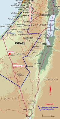
This website aims to present the results of the Archaeological surveys, excavations and studies as well as a database of the ancient desert agriculture sites. The last studies dated the systems to the 5th - 8th centuries C.E. and found that their distribution area spans about 5,000 sq. km. - twice the area that was estimated until recently.Area Map: The boundaries of the ancient desert agriculture. It covers the Northern Negev, the Negev Highlands, some part of the Palestinian Authority south to Gaza and an unknown area in Egypt, between the border with Israel and Wadi el-Arish, ca. 50 km westward.
What are the Ancient Agriculture Systems in the South of Israel?
The southern periphery of Israel, the Negev, is an arid desert that does not allow for agricultural activity, mainly due to the poor annual rainfall - 80 mm - considerably less than the 200 mm minimal amount required to grow grains. Fig 1 Fig 2Despite the environmental constraints, the entire area has an abundance of remnants from ancient desert agriculture, which are a dominant element in the landscape. Fig 3
Several well preserved ancient towers are included in that large-scale settlement: Beer Sheva, Malhata, Halutza, Nitzana, Shivta Fig 4, Avdat Fig 5, Rehovot and Mamshit.
The studies of the agricultural remnants can be classified to three different aspects:
The answers to some of the above questions fall into two main categories. One category, search for evidence of climatic changes. The second category argues that the tremendous agricultural remains are evidence of considerable investment by the state in settling the peripheral region, to stabilize the frontier against nomads. Therefore, the settlers subsisted on their own crops during rainy years, and received subsidies during drought years. The group of researchers who support this view includes those who argue that the systems in the Negev were intended to absorb only a small amount of rainfall, similar to that which exists today, and could not have endured a more humid climate. Indirect evidence in support of this argument is found in the recent discovery of agriculture systems in the Beersheva Valley, where the amount of rainfall is about three times greater than in the Negev Highlands. Indeed, the agriculture systems in the Beersheva Valley differ in several aspects, e.g., they have much fewer installations for draining runoff rainwater from the slopes.
- Archaeological Aspect:
investigation of the geographical distribution of the ancient agriculture components, mainly through field survey, and dates, through excavations or pottery collection. As we have seen today, ancient agriculture systems are scattered over an area of about 5,000 km - twice the area that was estimated until recently. Evidently, the agriculture systems are scattered not only in the arid part of the Negev but also farther north, to the area of the Beersheva Valley. Remnants of this agriculture include:Terraced wadis:
Several thousand km of wadis terraced by stone walls (10-100 m. long and up to 2 m. high) that accumulate soil appropriate for agricultural cultivation. The total length of the terraced wadis in the Negev Highlands alone - not including the areas that were recently discovered in the Beersheva Valley - is estimated at several thousand km. and the area of the soil that has accumulated there is estimated at 350,000 dunam. The terraced wadis constitute the solution for the limitation of agriculture caused by the scarcity of cultivatable land. Fig 6Farmhouses:
Located near the terraced wadis. The number of the farmhouses is estimated in thousands. Fig 7, Fig 8Agricultural installations:
An enormous number of installations have been found in association with the agricultural systems:
Cisterns Fig 9
Threshing floors Fig 10
Wine presses Fig 11, Fig 12
Channels to harvest runoff rain water from mountain slopes. The system of channels, directing runoff rainwater from a large area to the terraced wadis, constitutes the solution to the limitation caused by the poor rainfall. The total amount of rainfall channeled to the wadis is about 400 mm, about five times more than the general amount of rainfall - although this did not solve the problem of drought and the unstable rainfall regime. Fig 13, Fig 14
Tuleilat el Anab (grape mounds in Arabic) Enigmatic fields of stone heaps (measuring 1 m. in diameter and .30 m. in height), some of which span an area several sq/ km. The prevailing assumption is that they were intended to enhance the flow of run-off water into agricultural terraces. Fig 15
- Aspect of Historical Background:
investigating the historical circumstances and background that led to the establishment of the ancient agriculture systems. In the past, the agriculture systems were dated to the Nabateans period (2ed century B.C. - 2ed century C.E.) and were attributed to the Nabateans' ability to adapt to the desert environment. For about two decades, it has become clear that the agriculture systems were built much later, during the Byzantine period, apparently in the 5th century C.E. In addition, it is becoming clear that settlement did not cease at the end of the Byzantine period, but rather proliferated deeper into the desert during the Umayyad period and continued until the middle of the eighth century C.E. The presence of similar systems in the sedentary land north of the Beersheva Valley, as discovered recently, proves that this was a large-scale frontier settlement initiated by the state and the whole issue of the historical background should be revised.
- Physical-Environmental Aspect:
investigating the mechanism of the systems and their functioning from environmental aspects: climate, hydrology, botany, geomorphology and more.
The remnants of ancient agriculture reflect a tremendous investment in the construction of artificial fields - way beyond the size of the population that lived in the settlements and in the agricultural farms. Notwithstanding the abundant studies, it seems that there are still more questions than answers related to this aspect. For example, how did the loess soil accumulate in the artificial terraces, what was the function of the Tuleilat el-Anab? Did the agriculture systems function? If so, how efficient were they? Did those systems enable subsistence in a desert climate? Was the climate different?
The installations by the agricultural farms, which included wine-presses, threshing floors, and a large quantity of cisterns, reflect a functioning system. Considering the desert climate, it is clear that during drought years, when there was little or no rainfall, the fields did not yield crops and the population remained without food. What happened to the population then? Did the state subsidize peripheral settlement?
History of the Research
The existence of ancient agriculture systems and settlements such as farmhouses, farmsteads, villages and cities in the Negev has aroused considerable attention since the beginning of modern archaeological research. Among earliest modern researchers were Palmer (1870) and Woolley and Lawrence (1915) who conducted field surveys and described the systems and Huntington (1912), who attributed the existence of agriculture systems in the desert to climatic changes.In the 1930s, excavations were conducted at Tel Nitzana, an ancient city in the Negev. The discovery papyri archive in the site, which included documents of daily life, shed light on the historical aspect of the ancient agriculture systems in the Negev in the 5th to 7th centuries C.E. (Kraemer 1958; Colt 1962). The papyri provide clear evidence that the residents of the area engaged in agriculture, including cultivation of vineyards, and they paid taxes as well.
In the 1950s and the beginning of the 1960s, the Negev was surveyed by Glueck (1959) on a much larger scale than in previous studies. Although his scientific research did not focus specifically on agriculture systems, he mentioned their extensive distribution and the intensity of the finds. Glueck's work in the Negev had two long-term impacts to the study of ancient agriculture. First, it paved the way for a generation of scholars of the Negev, whether they were Glueck's direct disciples or whether they made indirect references to it (Aharoni 1960; Mayerson 1962; Rothenberg 1967). The second impact related to dating the Negev agriculture systems to the Nabatean period (2ed century BCE to 2ed century CE), and the continued existence of the systems in the Roman and Byzantine periods, up to the 7th century CE. In addition, Glueck attributed the existence of ancient agriculture systems in the Negev to the ability of the Nabateans to adapt to the desert environment in indeterminate ways.
A scientific breakthrough in research on the mechanism of ancient agriculture systems occurred in the mid-1950s, when a research team headed by Evenari set up a research station near Avdat (Evenari, Shenan and Tadmor 1971). Evenari focused on the relevance of runoff rainwater management in explaining the mechanism of the ancient agricultural features, such as: terraced wadis, channels for collecting runoff rainwater, and the enigmatic phenomenon of Tuleilat el-Anab. Evenari showed that the runoff rainwater collection systems concentrate water from an area that is five times larger than the area in which the water actually drains. Thus, the average of 80 mm. rainfall, which is not sufficient for agriculture, expands to 400 mm. creating conditions like those of sedentary land. Evenari did not address the issue of the unstable rain regime and drought. In addition, he disregarded the large number of well-preserved farmhouses, which are built near agriculture systems, and are the key to the chronological aspect. The chronological aspect was totally ignored by Evenari and his dating of the systems was in accordance with the general trend to relate them to the Nabateans. Among the contributions of Evenari's work are his active attempts to grow trees and plants, as well as his suggestions about applying ancient methods for contemporary use, similar to the methods mentioned above in the present proposal. However, the conditions at that time did not allow to Evenari to put his suggestions into practice.
Another study conducted during the 1950s, which also focused on the mechanism of the agriculture systems, was conducted by Kedar (1957). Contra to Evenari that study emphasized the aspect of soil management. According to Kedar, ancient agriculture systems were intended to increase the accumulation of loess in wadis and create an infrastructure for agricultural activity.
As of the 1960s and 1970s, the research on the environmental aspect of ancient agriculture was accompanied by comprehensive archaeological-historical research, which focused on the ancient cities in the Negev such as Avdat, Shivta, Halutza and Rehovot. These studies examined the role of the Nabateans and their descendents in settling the Negev during all of the classic periods represented in the Negev, from the second century BCE to the seventh century C.E., with emphasis on the aspect of material culture, architecture, and analysis of historical sources. Some of the later studies emphasized the geopolitical aspect, and attributed the establishment of agricultural systems to the policy of the Byzantine Empire to stabilize the frontier and the periphery by encouraging agricultural settlement (Shaefer 1981; Rubin 1990). State-sponsored peripheral settlement would explain the establishment of such large-scale systems, i.e., state subsidies made it possible for these systems to exist during drought years.
In the mid-1960s, teams from the Archaeological Survey of Israel (sponsored by the Department of Antiquities and Universities) began working in the Negev. The survey aimed to systematically document remains in survey units of 100 sq km. ("survey map", based on standard map sheets of 1:20,000). The documentation included identification and mapping of every ancient remnant, as well as textual and photographic depictions of the field plan. Even though the survey was limited in scope in the beginning (Cohen 1981, 1985), it represents progress in mapping of ancient agriculture systems, and in the analysis and dating of the remains of structures located in the vicinity of agriculture systems. The absence of Nabatean finds linked to ancient agriculture systems is particularly noteworthy. However, these finds did not affect the concepts of dating the ancient agriculture to the Nabatean period.
Significant progress in the documentation of agriculture systems, including archaeological excavations, was made in the frame of the Negev Emergency Survey, conducted by Dr. Rudolph Cohen from 1979 to 1990. The survey was intended to document the Negev areas, to which the Israel Defense Forces were supposed to retreat following the peace treaty with Egypt. Ten teams worked on the project, and systematically surveyed about 5,000 sq km of the area. About 12,000 archaeological sites were documented (as opposed to 1,000 that were known until that time). Even though many of the survey results were published (Haiman 1986, 1991, 1993, 1999; Lender 1990; Rosen 1994; Avni 1995; Baumgarten in press), there is still a considerable amount of material that has not been published, and that has not even been adequately studied. Notably, the survey results revealed no link between ancient Negev agriculture and the Nabateans. In fact, the evidence indicates that ancient Negev agriculture continued during the early Islamic period, up to mid 8th century C.E. In light of the findings of the Negev Emergency Survey, which include documentation of many hundreds of farm houses and excavations in some of those houses, it appears that the agricultural systems should be dated to the 5-8 centuries C.E., and that they should be viewed as peripheral Mediterranean agricultural settlement during the Byzantine Empire (Haiman 1995), of the type that was known in North Africa as early as the Roman period (Barker 1996; Mattingly 1996).
From the 1970s on, further progress was made in studies on the environmental aspect of ancient agriculture systems, as researchers examined the flow of runoff rainwater, conducted geomorphological tests of agricultural terraces (Yair 1983; Lavee and Yair 1987; Yair 1994; Lavee, Poesen and Yair 1997). One of the important conclusions reached in these studies, is that the systems were intended to function with a rain load that is similar to that of today. Another study, by contrast, dealt with fluctuations of reservoirs in Israel during the ancient period. According to that study, the climate during classic periods was more humid, and allowed for the existence of ancient agriculture in the Negev (Issar and Bruins 1983). Another progress of the last two decades includes research and tests of adaptation of vegetation to the desert environment, conducted by the Jewish National Fund. The studies dealt with forestation, soil stabilization, and collection of runoff rainwater in the Negev including in ancient agriculture systems.
A review of the history of research on the topic reveals that the studies have no relationship to each other. Studies on the environmental aspect did not address historical or archaeological questions. Concomitantly, archaeological excavations in major sites, such as Avdat, Rehovot and Nitzana, ignored the results of surveys and the excavations conducted in agricultural farms. The archaeological surveys completely disregard not only the environmental aspects, but also the historical aspects - mainly due to the abundance of new finds. This being the case, the research literature today may presents completely contradictory conclusions and perspectives.
Surveys and excavations carried out by the principal demonstrator of this proposal over the past three years, under the auspices of the Israel Antiquities Authority, indicate that the sedentary land in the north of the Negev Highlands, e.g., the Beersheva Valley, contains abundant remains of ancient agriculture systems of the type found in the Negev Highlands These are new discoveries, and have been presented so far only on a preliminary basis (Haiman, Haiman and Fabian, forthcoming). These discoveries have a decisive impact on the conclusions of previous studies. In the attempt to reexamine ancient agriculture systems in the Negev, this author initiated contacts with scholars from various disciplines such as geomorphology, hydrology and geology, in order to conduct interdisciplinary research. To date, a new survey was conducted in Nitzana, and an excavation in Tuleilat el anab field near Nitzana. Additional studies will be conducted during the present year. These studies are being conducted with the cooperation of the Israel Antiquities Authority, Bar Ilan University, the Weizman Institute, the Jewish National Fund, and the Nitzana.
Literature cited
Aharoni Y.; Evenari, M.; Shanan, L.; and Tadmor, N.H. (1960). The Ancient Desert Agriculture of the Negev. Israel Exploration Journal 10: 23-36.Avni, G. (1992). Map of Har Saggi - Northeast (225). Jerusalem: The Israel Antiquities Authority and the Archaeological Survey of Israel.
Barker, G. (ed) (1996). Farming the Desert, The UNESCO Libyan Valleys Archaeological Survey. Volume one. UNESCO.
Baumgarten, Y. (Forthcoming). Map of Shivta (166). Jerusalem: Israel Antiquities Authority and the Archaeological Survey of Israel, Jerusalem.
Bruins, J.H.(1985). Desert Environment and Agriculture in the Central Negev and Kadesh Barnea During Historical Periods. Nijkerk, the Nederlands: MIDBAR foundation.
Cohen, R. (1981). Map of Sde-Boqer East (168). Jerusalem: Archaeological Survey of Israel.
Cohen, R. (1985), Map of Sede-Boqer west (167). Jerusalem: Archaeological Survey of Israel.
Colt, H. D. (ed) (1962). Excavations at Nessana 1, London.
Evenari, M.; Shanan, L.; and Tadmor N.H. (1971) The Negev. The Challenge of a Desert. Cambridge, MA: Harvard University.
Glueck, N., (1959) Rivers in the Desert, London: Weidenfld and Nicolson.
Haiman, M. (1986). Map of Har Hamran South-West (198). Jerusalem: The Archaeological Survey of Israel.
Haiman, M. (1990). Map of Mizpe-Ramon (200). Jerusalem: Israel Antiquities Authority and the Archaeological Survey of Israel.
Haiman, M. (1993). Map of Nahal Aqrab (199). Jerusalem: Israel Antiquities Authority and the Archaeological Survey of Israel.
Haiman, M. (1995). Agriculture and Nomad-State Relations in the Negev Desert in the Byzantine and Early Islamic Periods, Bulletin of the American Schools of the Oriental Research 279:5-29.
Haiman, M. (1999). Map of Har Ramon (203). Jerusalem: Israel Antiquities Authority and the Archaeological Survey of Israel.
Huntington, E. (1912). Palestine and its Transformation. London.
Issar, A. S. and Bruins, H. J. (1983). Special climatological conditions in the deserts of Sinai and the Negev during the latest Pleistocene. Paleaogeography, Palaeoclimatology, Palaeoecology, 43:63-72.
Kedar, Y. (1957). Water and Soil from the Negev: Some ancient achievement in theCentral Negev. Geographical Journal 123:179-189.
Kraemer, C. J. (1958). Excavations at Nessana 3, Non-Literary Papyri, Princeton.
Lavee, H. and Yair, A. (1990). Spatial variability of overland flow in a small arid basin. Erosion, Transport and Deposition Processes, Proceedings of the Jerusalem Workshop, March-April 1987. IAHS Publ. no. 189.
Lavee, H., Poesen, J. and Yair, A. (1997) Evidence of High efficiency water-harvesting by ancient farmers in the Negev Desert, Journal of Arid Environments 35:341-348.
Lender, Y. (1990). Map of Har Nafha (196). Jerusalem: Archaeological Survey of Israel
Mattingly, D. (ed) (1996). Farming the Desert, The UNESCO Libyan Valleys Archaeological Survey. Volume two. UNESCO.
Mayerson, P. (1960). The Ancient Agricultural Regime of Nessana and the Central Negev. London.
Negev, A. (1986). Nabatean Archaeology today. New York.
Palmer, E. H. (1871). The Desert of the Exodus. London.
Rosen, S. A. (1994). Map of Makhtesh Ramon (204), Israel Antiquities Authority, Jerusalem.
Rothenberg, B. (1967). Negev, Archaeology in the Negev and the Arabah. Ramat Gan -Givataim: Masada. (Hebrew).
Rubin, R. (1990). The Negev as a Settled Land. Jerusalem: Yad Izhak Ben-Zvi and The Israel Exploration Society. (Hebrew).
Shaefer, J. (1981). The Ecology of the Empires: An Archaeological Approach to the Byzantine Communities of the Negev Desert. Ann Arbor, Michigan: University Microfilms International.
Tsafrir, Y. (ed) 1986. Excavations at Rehovot-in-the-Negev, I, The Northern Church, QEDEM 26. Jerusalem: The Hebrew University
Woolley, C.L., and Lawrence, T.E. (1915) The Wilderness of Zin, Palestine Exploration Found Annual III (1914-1915). London.
Yair, A. (1983). Hillslope hydrology water harvesting and areal distribution of some ancient agricultural systems in the northern Negev desert. Journal of Arid Environment 6: 283-301.
Yair, A.(1994). The Ambiguous Impact of Climatic Change at Desert Fringe: Northern Negev,Israel. In: Milington, A.C. and Pye, K. (eds.), Environment Change in Drylands: Biogeographical and Geomorphological Perspectives, John Wiley & Sons Ltd, pp. 199-227.
Archaeological Survey Map No. 198
"Survey Map" is a standard unit of 100 sq. km. used to conduct surveys in the Israel Antiquities Authority since 1964. The area of Survey Map No. 198 is located in the western Negev Highlands where many agricultural farms from the Early Islamic Period (7-8th Centuries C. E.) were found.This survey area marks the starting point of our GIS Database which will allow entry through a smart text search which dynamically plots matching sites, then links to available GIS and textual information. We plan to add survey maps to this centralized database until all of the surveyed areas can be made accessed with one search.