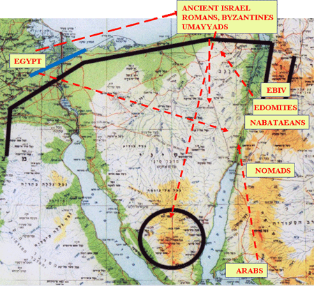
At the center of the ADASR Project are Grids 198, 199, and 200, as can be shown by clicking HERE on our ADASR mapping application in a GIS environment. A fact not always remembered is
that this area of the Negev is one of the world's most ancient
zones of ongoing conflict going back thousands of years. Therefore,
a primary goal of our project has been to create a unified,
intelligently searchable database, which links all the related data about this area.
Click to download and view
Conflict Analysis PowerPoint Presentation

The study of the ancient social dynamics in the Southern Levant desert which constitutes the land bridge between Asia and Africa, provides a framework for correlation of the physical remains, frequent cultural changes, historical sources, influence of all ancient and modern powers, and relations with the harsh environmental condition in terms of subsistence. By documenting the archaeological record into a high resolution GIS format, the pooled research becomes a source for multi-disciplinary studies in the present which can help us to resolve modern day conflicts containing similar factors.
The Middle East has been the stage of conflict for longer than most others in the world. In this downloadable PowerPoint Presentation for qualified viewers, you can see a selection of ancient conflicts which have occurred in the southern Levant desert, pre-dating more familiar ones not shown, such as the Crusades, the Middle Ages, and Modern period conflicts such as Napoleonís invasion, World War I, and the ongoing and current Israeli-Arab conflict.
If you are a professional with an academic or professional association,
you can download and view a Powerpoint presentation which details
this subject more clearly, as well as
several related comprehensive Powerpoint presentations which will
give you a substantial amount of information about our project. These
are available by id and password only, which we will make available
to qualified professionals with verifiable affiliations.
If you are interested in viewing these presentations, please fill out
our form, submit, and we'll
get back to you accordingly.
You'll need Powerpoint installed on your system to view these
copyrighted presentations.
Please remember these are copyrighted presentations and not for
distribution, redistribution, or excerption whatsoever, without our permission.
Click Here for More Presentations

