|
CRASL Projects
CRASL projects are directed by Dr. Jessie A. Pincus, of Bar Ilan University,
University of Miami, and Texas A&M University.

Dr. Jessie A. Pincus looks out over the Kotel in Jerusalem during her summer research 2010

|
- Underground Jerusalem Heritage Trail
Since 2003 we have been working to create a sub-surface map of the Upper City of Jerusalem prior to the Roman Destruction. The initial surveying and extensive GPR work was executed at the Church and Hospital of St. Mary of the Teutonic Knights that sits above the Roman Destruction and at the apex of what was the remains of the historic Upper City.
In the summer 2010 season we added 4 new grids of acquired GPR data at the same level as the Roman destruction of the city in 70 CE. Portions of this area were said to be later utilized during the Byzantine period in the creation of the famous Nea Church. These surveyed areas link to the surrounding archaeological sites and thus sub-surface stratigraphy of the city can be continued. In the coming summers we plan to add more "dots" to our map.
After the city was damaged during the 1967 war, intense archaeological excavation was completed. Many areas were also simply filled in for preservation and will not be further excavated in coming years. A sub-surface underground map of the cavities that many buildings are built upon will aid in the creation of heritage tours delineating the city's destruction by the Romans in 70 CE, as well as aiding in potential prevention of building collapse that people are presently living in on top of the yet unknown cavities they are built upon.
With the enormous increase of tourists to the Old City of Jerusalem in coming years and the historical importance of the sites there will be numerous opportunities for collaborations as this project unfolds.
|
|
- Finding the Lost MIA's of Israel
After many many hours of field and historical research from 2003-2006, working with the MIA office, and considerable financial investment undertaken personally,we were able to resolve a long mystery about the Israeli MIA, and bring peace and honor to the family after many years of wondering. The final end to a young Israeli immigrant in 1948 who fought in the War of Independence was finally determined, with the results approved by the Chief Rabbi of Israel, recognized by the family, and announced to the public on Israel Independence Day, Yom HaAtzma'ut, in 2007.
From the last accounting we were given, there are a total of at least 128 fallen soldiers with no headstones, from the days of early Israel up to the present. Of this number 47 are thought to be in similar geologic circumstances which would have a high probability of being located using geophysical survey techniques, given that we have the means and resources to focus on the task. The stories of all 128 need to be fully researched, documented, and told. The geophysical study for the first has been completed, and a study begun for the second. The memory of these individuals who gave their lives for Israel needs to be recorded; their stories should be a matter of record for their progeny, their families, and for all of us that follow. CRASL is seeking funding to complete this project and welcomes your support.
|
|
Jessie Pincus hefts the GSSI 200 MHz Antenna in 2004 at the Tell es-Safi/Gath Archaeological Project tracking the ancient siege trench which surrounds the Tell

|
- Tell es-Safi/Gath Archaeological Project
Since 2003 we have worked at the Tell es-Safi/Gath Archaeological Project bringing high technology techniques
to traditional archaeology. Tracking the siege trench using GPR
provided one of the largest contiguous studies done to date, working
with Dr. Aren Maeir of Bar Ilan University, Archeological Director of the site.
Ongoing collaborations with researchers from the Weizmann Institute of
Science and Bar Ilan University have provided a unique opportunity
for students to get involved in different methods of archaeological
science. The work is
integrated into the regular field work of the project. Photos courtesy of the Tell es-Safi/Gath Archaeological Project Weblog.
")
Weizmann Institute Archaeological Field Laboratory 2010
(photo courtesy of Tell es-Safi/Gath Archaeological Project)
|

Tell es-Safi/Gath 2010 summer excavations
high atop the Tell
|
Moving forward we will continue to be involved in sub-surface mapping of areas of interest on the site. This site is one of the largest, if not THE largest tel-sites in Israel.
Follow the progress on the Tell es-Safi/Gath Archaeological Project Website here.
 Click for Summer 2014 GPR Study at Tell es-Safi/Gath Area P Click for Summer 2014 GPR Study at Tell es-Safi/Gath Area P
|
|
Exploring the Shepela, June 2013

|
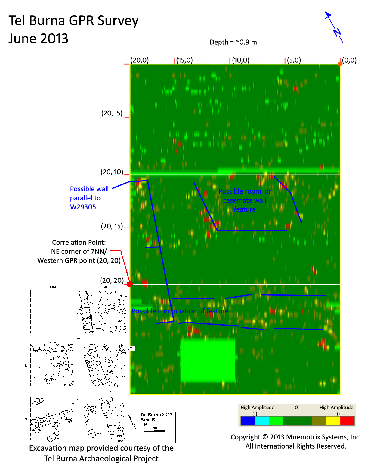
Tel Burna is a Bronze and Iron Age site (13th - 7th c. BCE) located in the Shephelah breadbasket region of the southern part of Israel. It has been suggested by scholars to be the Biblical Libnah. Libnah is mentioned in the Old Testament as an Israelite desert camp that Joshua encamped and fought against (Joshua 10:29-31; Joshua 12:15). Later it was given as a city to the children of Aaron, it joined the Edomites in a revolt against the King of Judah, and finally during the reign of Hezekiah, Libnah was besieged by Sennacherib (2 Kings 19:8, Isaiah 37:8).
Today the tel has a flat-topped shape, has an extensive size, and there are clear casemate wall fortifications dating to the 7th c. BCE surrounding it. What is unique about the site from an archaeogeophysical perspective is that we seem to only have a few occupation layers at the site, making it an ideal site for a case-study in archaeogeophysical method.
So far silos, floors, a Late Bronze period cultic area, figurines, and other great artifacts have been excavated at the site.
Some of the walls we are tracing in the GPR data at Tel Burna, June-July 2013

|
Check out how far we've come this summer, here. We've done
a GPR study of the area adjoining the Tel's existing excavation, and
are tracing the extension of these walls in the eastern side. Next
season we'll be able to investigate more closely.
Follow the progress on the Tel Burna website here.
See full GPR report from Summer 2013 season here.
See GPR depth slice animation here.
|
|
- Tel Yafo (Ancient Jaffa) - Ioppa Maratima
Tel Yafo
Courtesy of the Jaffa Cultural Heritage Project

|
Dr. Pincus joins the Jaffa Cultural Heritage Project
to provide geophysical support services to upcoming excavations at
the ancient port of Jaffa (Yafo) on the Mediterranean Sea just
south of Tel Aviv. This portion of the project is called
Ioppa Maratima.
Working with this prestigious UCLA project
she adds to the many talents of a multi-disciplinary
association of contributors. Watch the JCHP site for details.
|
- Tell el-Hesi Regional Projects
Tell el-Hesi

|
This is the site of an Islamic period khan or caravanserai (way-station). Khans of this period functioned as way-points along the trade routes and would offer nightly shelter and a place to buy supplies for travelers. The chief archaeologists of the project suspect certain sub-surface features under the soil, among other features yet to be further investigated.
There are many possibilities that can stem from this site south of Qiryat Gat due to its large size and occupation into modern periods.
Click for Summer 2011 Summeily GPR Study and Depth Slice Animation
|
|
- Avdat, The Hidden Roman City
Avdat was first established in the 1st c. BCE as a Nabatean center along the ancient spice route (see www.avdat.org). Settlement continued until late in the Byzantine to Early Islamic periods.
It is known that the Roman 10th Legion was based at Avdat for a significant period of time.
Byzantine Wine Press at Avdat seen in 2010

|
The huge wine press at Avdat is a testament to the socio-economic culture
wielded by the Byzantine churches extending over the wide range of
agricultural terraces in the valley. Dr. Pincus spent many years
doing hydrological studies in the region for her doctoral thesis.
We hope
to open new areas of archaeological research in the coming years,
beginning with non-invasive GPR studies.
A World Heritage Site since 2007, Avdat holds many undiscovered
mysteries.
|
|
- Einot Amitai near Nazareth
Major New Testament Discovery Summer of 2016
Dr. Jessie Pincus's GPR work over the last year at this site has paid off for archaeologists!
Jessie has been working with Dr. Yonatan Adler, the Chief archaeologist at the site, collaborating on this location since 2015.
 Archaeological excavations conducted in Galilee in early August, under the direction of Dr. Yonatan Adler of Ariel University, have unearthed a 2,000 year-old cave which functioned as a quarry and industrial workshop for the production of stone vessels. The large subterranean cavern, hewn into a chalkstone hillside, was discovered at a site named Einot Amitai near Nazareth in northern Israel. The cave yielded numerous remains of stone vessels in various stages of production, attesting to a thriving industry.
 "Stone vessels played an integral role in the daily religious lives of Jews during this period" explains Dr. Adler, an archaeologist specializing in ancient Jewish ritual law. "It was a Jewish 'Stone Age' of sorts".
The practice is mentioned prominently in the Wedding at Cana narrative in the Gospel of John, where the water-turned-to-wine is told to have been held in six jars made of stone:
"Now there were six stone water jars set there for the Jewish custom of purification, containing twenty or thirty gallons each" (John 2:6).
 Click for Arutz Sheva Article Click for Arutz Sheva Article
Click for Times of Israel Article
Click for BAR Article
Jessie has been the chief geophysicist at the site. Initial GPR surveys were conducted and the first ground truthing work (excavation) followed. All their hard work has paid off. This is very important as the site connected with the first miracle of Jesus in the New Testament.
Support Our Projects!
|
|
|
|