Mnemotrix Systems, Inc. was asked to assist in a project to determine ifGPR could be useful in resolving instances where a lack of clarity remained regarding certain historic burials. Having a willingness to assist, Mnemotrix agreed to undertake a test survey on one particular plot marking a burial from the late 1940's, where 7 people were known to be buried, and are respectively marked by 7 headstones. There exists, however, a question as to whether a particular 8th person may have been also buried in this plot, at that time.
The overall cemetery architecture and memorialization was put into place many years subsequent to the actual burials, necessitating groupings of headstones and burial plots which do not begin and end precisely over the space of each respective burial. Therefore, we were advised to be alert to groupings which might overlap beneath the surface.
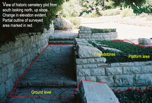
The section of the cemetery on which we did the survey was built up the side of a northward sloping hill. Our plot was located about halfway up this hill, so this slope was a key feature of the GPR survey which had to be accounted for.
A key feature, as well as obstacle, to collecting GPR data on this plot is the presence of the 7 headstones which are each about 40 cm high. When the changing elevation factor is added, this gives up to 80 cm of added height from the ground level on the selective areas where we traversed the headstones which had to be factored into the analysis of the GPR data.
The bushes east (left) of the headstones sit on a lower level platform, which sits on an even lower ground level walkway. The only way to collect GPR information for the entire space was to traverse up and down all these obstacles, and resolve the height discrepancies in post-processing.
The next figure, looking north, shows the differences in height, over which the GPR antenna was carried up and down. The platform area on which the headstones rest averages about a half meter above the flagstone walkway on the southern side, and is closer to a quarter meter on the northern side. The headstones themselves are again higher than the bushes by at least 40 cm.
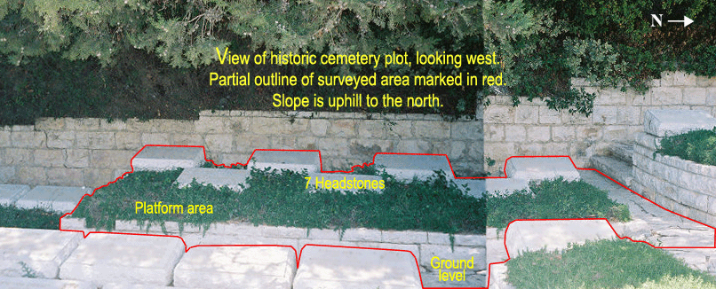
The next figure, looking west, shows the situation of the plot, and most closely resembles the perspective of the GPR grid which was marked out. The area marked out was 3.7 meters in an East/West direction, and 5.2 meters in a North/South direction. Data was collected in both directions and assembled into a super 3D grid for post-processing. The 7 headstones can be clearly seen.
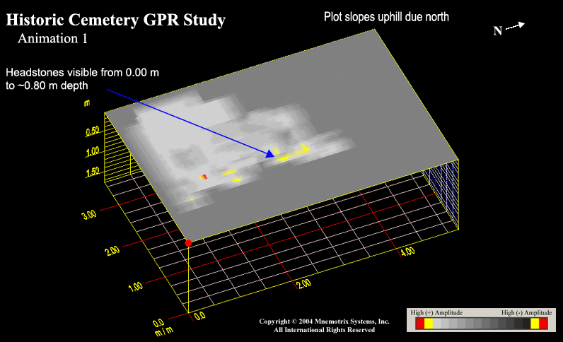
The investigators were interested only in the sub-surface results to a depth of about one meter below the surface, and we were interested in obtaining as high resolution as possible. Therefore, we chose to use the 400 MHz antenna, with a shallow profile using a 60 nanosecond window, which would allow us a viewing window of about 1 - 3 meters. Lines were acquired as close together as practical, from 20 cm - 40 cm apart where possible. The dimensions of this first grid were 5.2 m (N/S) x 3.7 m (E/W). What we discovered in post-processing analysis, was that the signatures of the individual burials could indeed be differentiated from the obstruction of the headstones, by carefully watching in which depth slice certain features appeared. Therefore, before our analysis was confirmed, we constructed a comprehensive depth slice animation in which we could slowly watch each anomaly as it appeared, and begin to group features together.
We found that, as would be expected, the headstones could be seen to completely appear from the top of the acquired dataset down to ground level; then, for about 0.5 meters below the surface, the burial signatures appeared, and then disappeared. Once this was clearly established, we were able to watch to see which features appeared at once, and begin to group them into what could be postulated to be the signatures of individual burial remains. It is presumed that these burials would have been largely made in wooden boxes, and that over a period of 60 - 70 years the remains would have encountered a large degree of disintegration. On that assumption, we were able to trace features which appeared similar, burial to burial, which appeared to contain a space within another feature surrounding it somewhat.
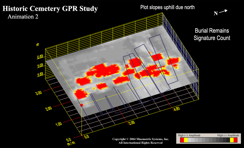
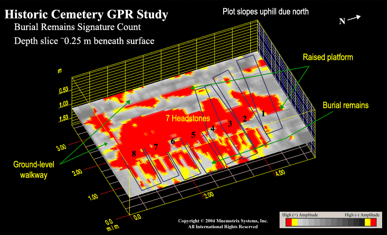
The most complete view of this, at a depth slice of about 0.25 meters beneath the surface (ground level) is shown in the next figure. Note that ground level is about 0.8 meters below the top most depth slice seen in our GPR images. The anomalies, or what we believe to be individual burial signatures, are numbered right to left, 1 - 8, because that is the order in which they first appear in the animation which goes from top to bottom. This makes sense when the slope is taken into account. The GPR study proceeds "straight" down, but it is in fact higher on the north side than on the south side. Nevertheless, the bodies would have been buried at a relatively consistent depth, side by side.
What we found was that by our best adjudication, 7 (noted by numbers 2-8) distinct and similar anomalies could be seen for about half a meter, beginning just beneath ground level; and which could be correlated to the 7 burials fully documented and marked by the 7 headstones. In addition to this, an 8th anomaly (the first to appear by depth, and marked as number 1) on the north side, almost identical to the other 7, could be seen. It is positioned at a slightly different angle, pointing slightly more to the north and to the west, but it is appearing at the same depth beneath ground level as the other 7. More of this same anomaly is visible on the western side of the headstones than with the other 7; therefore we are seeing less of the anomaly on the eastern side. Since the headstones are obscuring the view of everything in the mid-section, this obstruction must be factored into the viewing of all 8 anomalies.
After careful and responsible consideration of the data available to us, we have concluded that the preponderance of evidence weighs towards the probability that there may indeed be 8 rather than just the 7 documented burials in this plot.