Tell es-Safi, Israel, Summer 2004 - 2005
Tracking the Trench
Plotting the Course of the Trench: Conclusions Return to Whole Trench Study |
Ground Truth Study 2005
Return to Whole Trench Study |
Ground Truth Study 2005 
Return to Whole Trench Study |
Ground Truth Study 2005
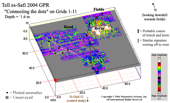
A fairly consistent anomaly can be seen and traced throughout the area, starting with the control study (Grid 12) and working its way downslope north towards the fields. We studied the individual grids (which allows for higher 3D resolution) to locate what seemed to be a similar anomaly, or GPR "signature" denoting where the trench might be. We plotted their location on the Super-3D GPR grid below using black dots.The distance between the cluster of dots to the west and to the east is about 23 meters towards the middle of our survey area at a lower elevation, so it seems unlikely this distance could represent two sides of a siege trench. The berm area can be seen visually where noted to the east as a raised area, as that area has been left relatively undisturbed, while the area coming closer to the road and beyond it has been cleared, cultivated, and planted.
The area at the top of the hill is located just beneath and north of the excavated trench area, and is between two boulder areas. According to Dr. Maeir, looking at the ancient and modern landscape, this section should be directly in the trench, with berm remnants to the east. Therefore it seems logical to connect the dots coming down the hill and veering to the east as shown. This can be seen in the figure below where black lines mark "probable course of the trench and berm".
The cluster of "dots" or similar GPR signature to the west could indicate something from the same time period, or at least something which would leave the same trace on the sub-surface as would the trench. A follow-up ground truth study on both areas will shed light on this subject, perhaps next season.
Click on the individual grid areas of the Super-3D grid above to see a closeup GPR signature which runs through the area. Animations of the full range of depth slices can also be seen for our control study, Grid 12, where the trench had been excavated in previous seasons, and for Grids 9, 10, and 11, which covered the next accessible area extending down the steepest portion of the slope.
| Grid 1 | Grid 2 | Grid 3 | Grid 4 | Grid 5 | Grid 6 | Grid 7 | Grid 8 | Grid 9 | Grid 10 | Grid 11 | Grid 12 |
Return to GPR Trench Study Introduction